BIM & Fisheries Management Map 2013
 Bord Iascaigh Mhara (today 1 May 2013) launched its Fisheries Management Map 2013.
 Bord Iascaigh Mhara (today 1 May 2013) launched its Fisheries Management Map 2013.
 Bord Iascaigh Mhara (today 1 May 2013) launched its Fisheries Management Map 2013.
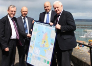
L-R: Sean O’Donoghue, BIM Board Member, John Coleman, CEO, La Tene Maps, Daragh Browne, gear technologist, BIM and Kieran Calnan, chairman, BIM Board at the launch of BIM’s 2013 Map For Fisheries Management
“The 2013 edition of the Map brings together for the first time, in one place, all of the areas around Ireland affected by closures or recovery plans or additional gear requirements,” says Michael Keatinge, Director of Fisheries and Training Services, BIM.
Other significant changes to this year’s Map cover the inclusion of a fully revised and extended mesh size and catch composition table. There will also be new tables and diagrams covering the static year. A map for Nephrop Functional Units is also a new feature as is the Map’s showing of six and twelve-mile fishing rights.
BIM has begun distributing copies of the 2013 Map. All registered vessels over 15 metres automatically receive a printed copy of the Map. Any other registered vessel owners interested in receiving a printed copy of the Map should contact their local BIM regional office.
For a digital copy download the 2013 Map For Fisheries Management (pdf 1,537Kb)